 FR
Digital Tools for Groundwater Development
Practitioners and decision makers responsible for the development and management of groundwater resources rely on accessing good quality data to plan drilling works and calculate groundwater availability. Regulatory bodies in high-income countries store valuable geo-hydrological data for sector-wide knowledge sharing, the planning of drilling works, assessments of groundwater availability and other future uses. When boreholes are being drilled, detailed data is recorded and submitted to these bodies. Examples are the Geological Survey of the Netherlands (DINOLoket) and the British Geological Survey (BGS) in the United Kingdom.
In low-income countries, existing hydrogeological data is often either not available or scattered across different locations: held by the private sector for their own use, kept at the offices of NGOs or embedded in consultants’ reports — frequently only in paper format. Regulatory bodies are often poorly financed, and practitioners such as drillers or supervisors have little capacity to manage and capture data effectively. When new water points are created, no simple tools exist to capture, store and share the data that is generated in a digital format – such as geophysics results, drill logs, and pumping tests. Therefore, data is often not collected, is of poor quality, or lost over time.
The result is that projects and drilling works are planned ‘blind’ and data is not being made accessible and shared in the sector. This lack of data limits the implementation of cost-effective water programs.
We believe that capturing data in a digital format at the source is key. The rapid advances and availability of smartphones have made the collection and storing of data much easier, which presents a new opportunity to address this issue.
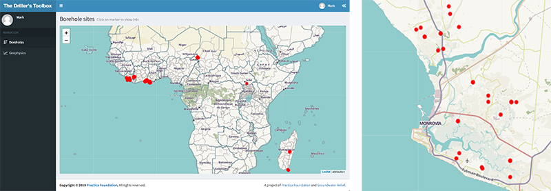
The online Drillers’ Toolbox dashboard, where reports can be accessed.
The Drillers’ Toolbox
PRACTICA Foundation, together with supporting partners Groundwater Relief and MSF, has developed a set of tools to capture geophysics, drilling and pumping test data in a digital format. This Drillers’ Toolbox consists of a smartphone app (android only) and an online dashboard. The toolbox complements existing databases and focusses on the field data collection process.
The Drillers’ Toolbox smartphone application has different modules that each specialise in capturing a particular type of data: resistivity geophysics data, drilling logs, and pumping test data. All data is georeferenced. Depending on future demand, we will consider adding additional modules to the app, such as water level monitoring and water quality measurements.
After capture of data in the app, data is submitted to the dashboard. Based on the data, a professional PDF report is generated and send to the user by email, including the raw data in excel format. In the dashboard, all data can be viewed on a map, and downloaded. A Web Feature Service (WFS) can be used to insert the data as a layer in existing GIS platforms. The app modules are described in more detail below.
The Drillers’ Toolbox app is available on Google Play and can be tested for free during a two-month period. Here is the User Manual.
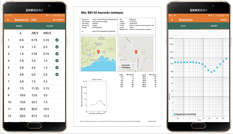
Screenshots and resulting PDF report page of the siting module.
Siting Module – Resistivity geophysics
This module captures resistivity data and can be used to do 1D Vertical Electrical Sounding (VES) or Horizontal Electrical Profiling (HEP) measurements. It includes data capture, calculation of resistivity, and visualization of measurements in a graph. The user receives a professional PDF report by email which includes the data, graphs, and modelling results. Any type of resistivity equipment can be used, such as an ABEM Terrameter, Syscal Pro or AGI Supersting. PRACTICA has also developed an affordable resistivity device, the Volterra 3, which gives identical results but is available for a much lower price.
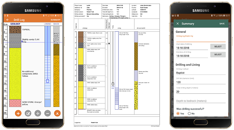
The drill log module.
Drill log module
This module captures data on geology, casing and screen installation, backfill, pump placement, and other relevant drilling data and well characteristics. International standards for lithology logging are used. The user receives a professional drilling log in PDF format by email.
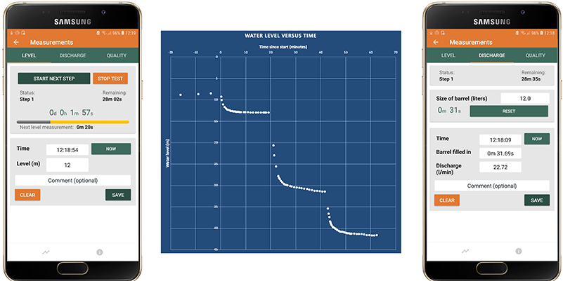
Screenshots and resulting PDF report page of the pumping test module.
Pumping test module
This module records and visualizes pumping test data, which is used to determine the sustainable yield of a borehole. Both step tests and constant rate tests are supported. Using the phone as timekeeper greatly simplifies the capture of timed water level, discharge and water quality data. The user receives a professional pump test report in Excel format by email.
Data & Usage
Data for all three modules is accessible through the online dashboard. Depending on the license, data is either publicly accessible or only accessible to the owner. We advocate for data to be as open as possible, with possible limitations of privacy and country laws. We support national governments with open data policies and assist in the process of digitizing existing sector data.
The Digital Toolbox apps and hardware were developed in 2018 and 2019. Currently, the drill log app and siting app have been tested and are being used in Liberia, Sri Lanka, Bangladesh, Ivory Coast, Zambia and Mozambique among others. Feedback from field usage is used to further improve the software. The results have been very positive, with sustained use of the tools after initial introduction.
Training
To use the tools effectively for improved data capture, data management and quality control, it is important that users receive adequate training. PRACTICA provides dedicate training packages on the different subjects, such as drilling supervision training, training on siting with resistivity measurements, and pumping test training. We train NGOs, drillers and supervisors.
Interested?
If you are interested in the digital tools for groundwater development, please contact us to find out more. You can also read this brochure. The Drillers’ Toolbox app is available on Google Play and can be tested for free during a two-month period. Here is the User Manual.